படிமம்:First century Iudaea province.gif
Jump to navigation
Jump to search

இந்த முன்னோட்டத்தின் அளவு: 152 × 209 படப்புள்ளிகள் . மற்ற பிரிதிறன்: 575 × 792 படப்புள்ளிகள் .
மூலக்கோப்பு (575 × 792 படவணுக்கள், கோப்பின் அளவு: 31 KB, MIME வகை: image/gif)

|
This map image could be re-created using vector graphics as an SVG file. This has several advantages; see Commons:Media for cleanup for more information. If an SVG form of this image is available, please upload it and afterwards replace this template with
{{vector version available|new image name}}.It is recommended to name the SVG file “First century Iudaea province.svg”—then the template Vector version available (or Vva) does not need the new image name parameter. |
சுருக்கம்
| விளக்கம் |
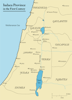
English: This is a map of first century Iudaea Province that I created using Illustrator CS2. I traced this image for the general geographic features. I then manually input data from maps found in a couple of sources.
|
| நாள் | 23 மார்ச் 2006 (original upload date) |
| மூலம் | Transferred from en.wikipedia to Commons. |
| ஆசிரியர் | Andrew c at ஆங்கிலம் விக்கிப்பீடியா |
| அனுமதி (இக்கோப்பை மீண்டும் பயன்படுத்துதல்) |
Released under the GNU Free Documentation License or CC-BY. |
| ஒத்தக்கோப்பு |
[]
|


அனுமதி
இந்த ஆக்கத்தின் காப்புரிமையாளரான Andrew c from en.wikipedia.org எனும் நான் இதனைப் பின்வரும் உரிமத்தின் கீழ் வெளியிடுகின்றேன்:

|
GNU Free Documentation License விதிமுறைகளின் கீழ் இந்த ஆவணத்தை நகலெடுக்க, விநியோகிக்க மற்றும்/அல்லது மாற்றுவதற்கு அனுமதி வழங்கப்பட்டுள்ளது, Free Software Foundation;ஆல் வெளியிடப்பட்ட பதிப்பு 1.2 அல்லது அதற்குப் பிந்தைய பதிப்பு, மாற்றமில்லாத பிரிவுகள், முன் அட்டை உரைகள் மற்றும் பின் அட்டை உரைகள் இல்லாமல் வெளியிடப்பட்டது. GNU Free Documentation License என்ற தலைப்பில் உரிமத்தின் நகல் சேர்க்கப்பட்டுள்ளது. Subject to disclaimers. |
This file is licensed under the Creative Commons Attribution 3.0 Unported license.
பண்புக்கூறுகள்:
Wikipedia User:Andrew c
- நீங்கள் சுதந்திரமாக:
- பகிர்ந்து கொள்ள – வேலையை நகலெடுக்க, விநியோகிக்க மற்றும் அனுப்ப
- மீண்டும் கலக்க – வேலைக்கு பழகிக்கொள்ள.
- கீழ்க்காணும் விதிகளுக்கு ஏற்ப,
- பண்புக்கூறுகள் – நீங்கள் பொருத்தமான உரிமையை வழங்க வேண்டும், உரிமத்திற்கான இணைப்பை வழங்க வேண்டும் மற்றும் மாற்றங்கள் செய்யப்பட்டிருந்தால் குறிப்பிட வேண்டும். நீங்கள் ஏற்புடைய எந்த முறையிலும் அவ்வாறு செய்யலாம், ஆனால் எந்த வகையிலும் உரிமதாரர் உங்களை அல்லது உங்கள் பயன்பாட்டிற்கு ஒப்புதல் அளிக்கும் படி பரிந்துரைக்க கூடாது.
Original upload log
The original description page was here. All following user names refer to en.wikipedia.
- 2006-03-24 18:48 Andrew c 575×792×8 (32374 bytes) This is a map of First Century Palestine that I created using Illustrator CS2. I traced [http://commons.wikimedia.org/wiki/Image:Map_of_administrative_regions_in_Israel.png this] image for the general geographic features. I then manually input data from m
- 2006-03-23 19:48 Andrew c 587×790×8 (30752 bytes) This is a map of First Century Palestine that I created using Illustrator CS2. I traced [http://commons.wikimedia.org/wiki/Image:Map_of_administrative_regions_in_Israel.png this] image for the general geographic features. I then manually input data from m
கோப்பின் வரலாறு
குறித்த நேரத்தில் இருந்த படிமத்தைப் பார்க்க அந்நேரத்தின் மீது சொடுக்கவும்.
| நாள்/நேரம் | நகம் அளவு சிறுபடம் | அளவுகள் | பயனர் | கருத்து | |
|---|---|---|---|---|---|
| தற்போதைய | 11:47, 18 செப்டெம்பர் 2011 | | 575 × 792 (31 KB) | wikimediacommons>Onceinawhile | Removed region-name "Philistia", as incorrect |
கோப்பு பயன்பாடு
பின்வரும் 20 பக்கங்கள் இணைப்பு இப் படிமத்துக்கு இணைக்கபட்டுள்ளது(ளன):
- இயேசு
- இயேசுவோடு தொடர்புடைய புதிய ஏற்பாட்டு இடங்கள்
- உருமாற்ற மலை
- எம்மாவு
- எரிக்கோ
- எருசலேம் கோவில்
- ஒலிவ மலை
- கப்பர்நாகும்
- கலிலேயக் கடல்
- கானா (விவிலியம்)
- கெத்சமனி
- கொல்கொதா
- செசாரியா கடற்கரையோரம்
- நாசரேத்து
- புதிய ஏற்பாட்டு இயேசு வரலாறு
- பெத்சதாக் குளம்
- பெத்தானியா
- பெத்பகு
- பெத்லகேம்
- வார்ப்புரு:New Testament places associated with Jesus