படிமம்:Ruhr area-map.png
Jump to navigation
Jump to search
மூலக்கோப்பு (1,000 × 593 படவணுக்கள், கோப்பின் அளவு: 86 KB, MIME வகை: image/png)

|
This locator map image could be re-created using vector graphics as an SVG file. This has several advantages; see Commons:Media for cleanup for more information. If an SVG form of this image is available, please upload it and afterwards replace this template with
{{vector version available|new image name}}.It is recommended to name the SVG file “Ruhr area-map.svg”—then the template Vector version available (or Vva) does not need the new image name parameter. |
சுருக்கம்
| விளக்கம் |
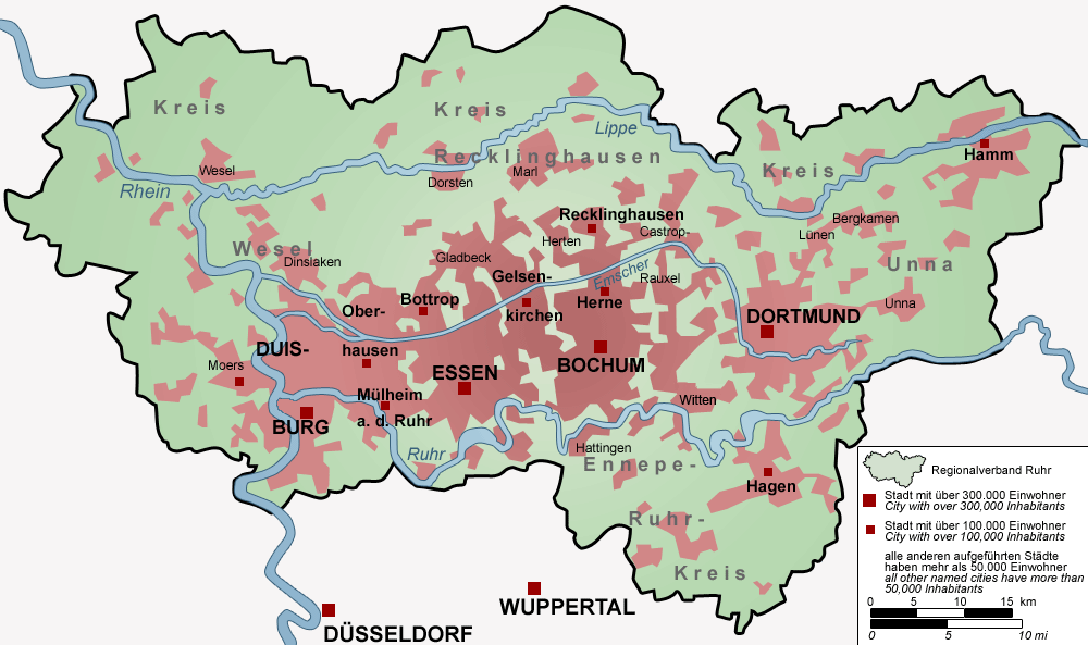
Deutsch: Karte des Ruhrgebiets, Deutschland – Die Karte zeigt das Ruhrgebiet (Regionalverband Ruhr) mit allen Städten über 50.000 Einwohnern.
English: Map of the Ruhr area, Germany – The map shows the Ruhr Area (Regionalverband Ruhr) with all cities with more than 50,000 inhabitants. |
| நாள் | |
| மூலம் |
சொந்த முயற்சி Deutsch: von mir selbst, Threedots (Daniel Ullrich), mit Adobe Photoshop 6.0 „gezeichnet“; Datengrundlage: GeoDaten des Landesvermessungsamts NRW (damalige URL: www.ruhrgebiet.de/daten/geodatenserver.shtml) und verschiedene andere Karten
English: "drawn" by myself, Threedots (Daniel Ullrich), with Adobe Photoshop 6.0; used data set: official GeoData (former URL: www.ruhrgebiet.de/daten/geodatenserver.shtml) and several other maps |
| ஆசிரியர் | Threedots (Daniel Ullrich) |
அனுமதி
இந்த ஆக்கத்தின் காப்புரிமையாளரான Threedots (Daniel Ullrich) எனும் நான் இதனைப் பின்வரும் உரிமத்தின் கீழ் வெளியிடுகின்றேன்:

|
GNU Free Documentation License விதிமுறைகளின் கீழ் இந்த ஆவணத்தை நகலெடுக்க, விநியோகிக்க மற்றும்/அல்லது மாற்றுவதற்கு அனுமதி வழங்கப்பட்டுள்ளது, Free Software Foundation;ஆல் வெளியிடப்பட்ட பதிப்பு 1.2 அல்லது அதற்குப் பிந்தைய பதிப்பு, மாற்றமில்லாத பிரிவுகள், முன் அட்டை உரைகள் மற்றும் பின் அட்டை உரைகள் இல்லாமல் வெளியிடப்பட்டது. GNU Free Documentation License என்ற தலைப்பில் உரிமத்தின் நகல் சேர்க்கப்பட்டுள்ளது. |
| இந்த கோப்பு Creative Commons Attribution-Share Alike 3.0 Unported உரிமத்தின் கீழ் உள்ளது. | ||
பண்புக்கூறுகள்:
| ||
| ||
| This licensing tag was added to this file as part of the GFDL licensing update. |
This file is licensed under the Creative Commons Attribution-Share Alike 2.0 Germany license.
பண்புக்கூறுகள்:
- நீங்கள் சுதந்திரமாக:
- பகிர்ந்து கொள்ள – வேலையை நகலெடுக்க, விநியோகிக்க மற்றும் அனுப்ப
- மீண்டும் கலக்க – வேலைக்கு பழகிக்கொள்ள.
- கீழ்க்காணும் விதிகளுக்கு ஏற்ப,
- பண்புக்கூறுகள் – நீங்கள் பொருத்தமான உரிமையை வழங்க வேண்டும், உரிமத்திற்கான இணைப்பை வழங்க வேண்டும் மற்றும் மாற்றங்கள் செய்யப்பட்டிருந்தால் குறிப்பிட வேண்டும். நீங்கள் ஏற்புடைய எந்த முறையிலும் அவ்வாறு செய்யலாம், ஆனால் எந்த வகையிலும் உரிமதாரர் உங்களை அல்லது உங்கள் பயன்பாட்டிற்கு ஒப்புதல் அளிக்கும் படி பரிந்துரைக்க கூடாது.
- அதே மாதிரி பகிர் – நீங்கள் ரீமிக்ஸ் செய்தாலோ, உருமாற்றம் செய்தாலோ அல்லது பொருளை உருவாக்கினாலோ, உங்கள் பங்களிப்புகளை அல்லது இணக்கமான உரிமம் கீழ் அசலாக விநியோகிக்க வேண்டும்.

நீர் உமக்கு விருப்பமான உரிமத்தை தேர்ந்தெடுக்கலாம்.
கோப்பின் வரலாறு
குறித்த நேரத்தில் இருந்த படிமத்தைப் பார்க்க அந்நேரத்தின் மீது சொடுக்கவும்.
| நாள்/நேரம் | நகம் அளவு சிறுபடம் | அளவுகள் | பயனர் | கருத்து | |
|---|---|---|---|---|---|
| தற்போதைய | 15:07, 8 சூன் 2010 | சிறுதோற்றம் இல்லை | 1,000 × 593 (86 KB) | wikimediacommons>NordNordWest | c |
கோப்பு பயன்பாடு
பின்வரும் பக்க இணைப்புகள் இப் படிமத்துக்கு இணைக்கபட்டுள்ளது(ளன):