படிமம்:Japan kyushu map small.png
Jump to navigation
Jump to search
இந்த முன்னோட்டத்தின் அளவு: 164 × 209 படப்புள்ளிகள் . மற்ற பிரிதிறன்: 235 × 300 படப்புள்ளிகள் .
மூலக்கோப்பு (235 × 300 படவணுக்கள், கோப்பின் அளவு: 6 KB, MIME வகை: image/png)

|
This map image could be re-created using vector graphics as an SVG file. This has several advantages; see Commons:Media for cleanup for more information. If an SVG form of this image is available, please upload it and afterwards replace this template with
{{vector version available|new image name}}.It is recommended to name the SVG file “Japan kyushu map small.svg”—then the template Vector version available (or Vva) does not need the new image name parameter. |
- What:
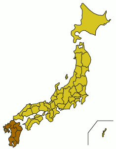
- English: A location map showing the location of Kyushu in relation to Japan.
- Latina: Charta geographica locum Ximi inter Iaponiam et eius provincias monstrans.
- Whence: From the English Wikipedia (Image:Japan kyushu map small.png), first uploaded by Synthetik.
Small map of Kyushu region
Map outline from public domain maps at http://aoki2.si.gunma-u.ac.jp/map/map.html

|
Shigenobu AOKI, the copyright holder of this work, allows anyone to use it for any purpose including unrestricted redistribution, commercial use, and modification. |
கோப்பின் வரலாறு
குறித்த நேரத்தில் இருந்த படிமத்தைப் பார்க்க அந்நேரத்தின் மீது சொடுக்கவும்.
| நாள்/நேரம் | நகம் அளவு சிறுபடம் | அளவுகள் | பயனர் | கருத்து | |
|---|---|---|---|---|---|
| தற்போதைய | 03:45, 5 பெப்பிரவரி 2005 | | 235 × 300 (6 KB) | wikimediacommons>Muke | From the English Wikipedia, {{PD}} |
கோப்பு பயன்பாடு
பின்வரும் பக்க இணைப்புகள் இப் படிமத்துக்கு இணைக்கபட்டுள்ளது(ளன):